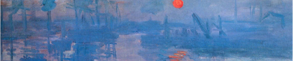
For centuries, artists and poets have tried to imagine the grandeur of ancient cities. In frescoes in the Vatican Raphael tried to reconstruct huge Roman buildings ; Coleridge wrote of Xanadu, ‘girdled round’ with ‘twice five miles of fertile ground’. Shelley’s Ozymandias invited his readers to ‘Look on my works, ye mighty, and despair!’
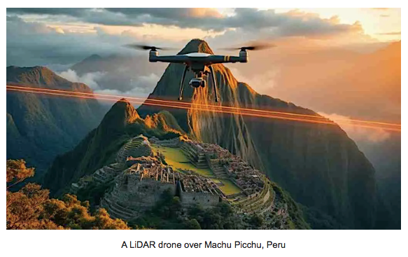
But the truth, as revealed by new technologies such as LiDAR (Light Detection and Ranging), is far stranger than any fiction or fantasy, whether painted or written. A remote sensing technology, LiDAR works by emitting thousands of laser pulses per second towards the ground from an aircraft or drone. Measuring the time it takes for each pulse to bounce back, it can provide data of the ground surface and any structures on it. By taking airborne readings from numerous different directions, it can present pictures of three-dimensional objects such as ramparts, ditches, roads and even buildings, forbiddingly difficult to reach through dense forest and even invisible to the naked eye from the air. LiDAR can “see” fine details of the landscape that were previously completely hidden from view. Forests and secondary foliage can be digitally cleared away to reveal the previously hidden outlines of ancient human settlements.
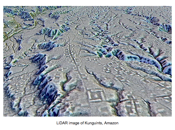
LiDAR has revealed the presence of vast civilisations in places where we had never suspected them and in the process it is actually helping to upend the entire history of civilisations that we were taught at school. That 4000 year seqential chain of development of civilisations we learned – from Mesopotamia to Egypt to Assyria to Greece to Rome- is being completely overturned. Two examples: we have traditionally been led to believe that the indigenous peoples of the Amazon Rainforest always led unsophisticated lives. Lives whose child-like simplicity has been used to justify their near extinction by loggers, cattle ranchers and growers of soy. Thanks to LiDAR the rainforest has been found to hide sophisticated ancient roads and buildings likely to be fully the match of anything of the same period in Europe.
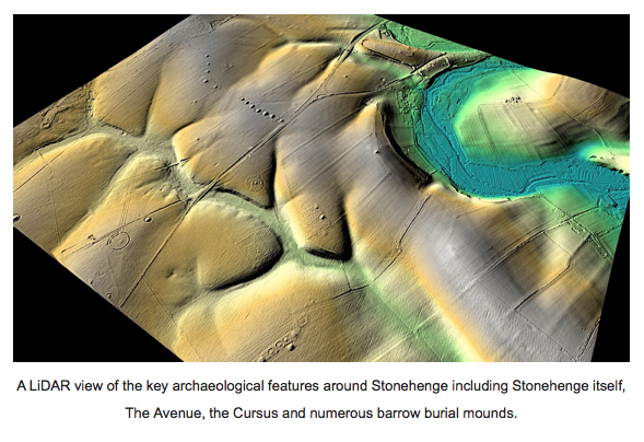
In the UK, Stonehenge was long thought to be a lone temple or observatory whose worshippers were the inhabitants of the recently discovered nearby settlement of Durrington Walls and/or pilgrims from the further away. It can now be seen to be at centre of numerous structures spreading over a vast acreage of Wessex, a central focus comparable to St Pauls in London. LiDAR is also suggesting that Stonehenge may be thousands of years older than has been thought, actually in use over a time period comparable to that between Ancient Egypt and the present day!
How have these discoveries been made? Not by speculative and invasive excavations. Not only would those be prohibitively expensive and take prodigious lifetimes to execute, they would be extremely damaging to structures both ancient and modern, wasteful of human labour and damaging to the planet. These and other revolutionary, completely non-invasive, technologies when applied to archaeology have rewritten the history of human habitation!
LiDAR technology, along with others such as Ground-Penetrating Radar (GPR), which unlike LiDAR can ‘see’ what lies beneath the ground surface, and Magnetometry, which maps anomalies in the earth’s magnetic field to find buried artefacts, is rewriting the history of human civilisation. Together these technologies constitute a revolution in how we understand our past, placing ancient Meso-America and Mexico’s peoples at levels of organization and political and social sophistication that equal those of Greece, Rome and post-Roman Europe. Ocumtun in Mayan Mexico is a completely new LiDAR discovery with a “monumental nucleus” covering more than 50 hectares, with pyramids, stone columns, altars, three plazas, and what may have been a Mayan ball game court. LiDAR is an absolutely thrilling technology, and for at least one archaeologist ‘makes my dreams come true.’
This course invites us to rethink our entire relationship, not only to the past, but to the present. Through an interdisciplinary approach, we will examine existing knowledge about these civilisations – the artefacts, structures, and texts that provide crucial insights into the daily lives, religious beliefs, and political systems of these long-gone societies. We will then see, with the new knowledge provided by LiDAR and its sister technologies, how we can open out that knowledge into new depths of understanding. We will discover mighty civilisations, megacities, in unexpected places, that were hitherto unknown. We will find that great buildings of antiquity were only the centres of cities whose extent can be directly compared with those of our own time. We will need to reconsider what we have hitherto considered as ‘primitive’, and in the process, question our own definitions of what it is to be ‘civilised.’ Those whom we had been thought to be distant and very different from us, are close.
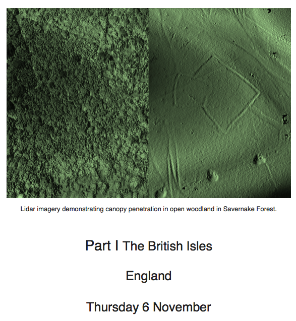
LiDAR is making huge discoveries in Savernake Forest, along Hadrians Wall, around Chichester, and along the banks of the Thames. Meanwhile, Stonehenge has been revealed as merely the centre of a vast and complex conurbation of up to 25 square miles in extent.
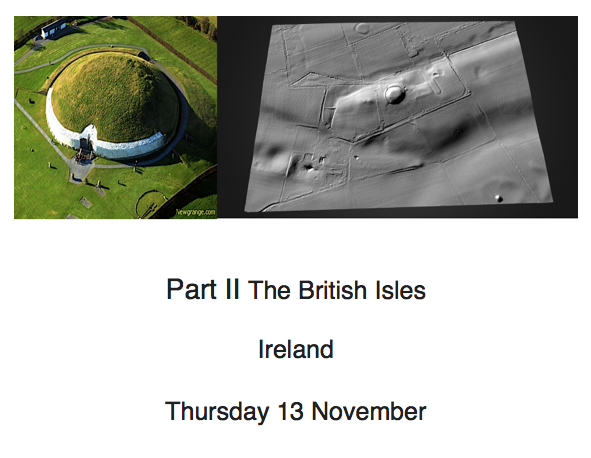
The ancient Neolithic site of Newgrange in the Boyne Valley (visited on a pre-Covid Inscape tour) is now also revealed as the centre of a much larger community. Our understanding of Baltinglass in County Wicklow, a hugely important site dating from the Stone Age through to the Normans and Cistercians, has also benefited from the revelations of LiDAR, as have more recent sites such as the Irish Famine burial site of Carrs Hill in Cork.
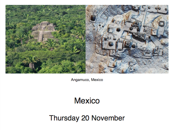
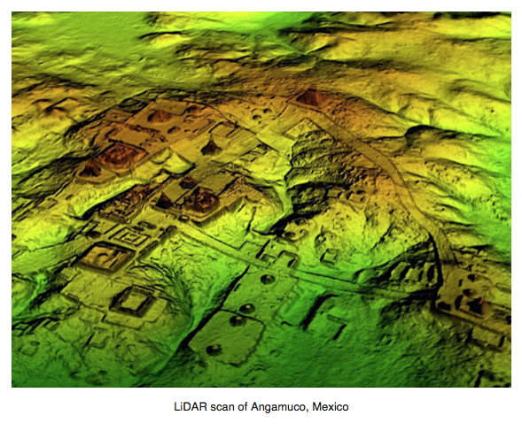
In 2012, using LiDAR, archaeologist Christopher Fisher discovered altars, pyramids, storage facilities, ball courts, patios, terraces and a hierarchical road system at Angamuco, about 300 km west of Mexico City. He realised it was a principal centre of the Purépecha culture that rivalled the Aztecs. By c. 1350 CE Angamuco covered ten square miles, housing a population of around 100,000, and an absolutely astonishing 39,000 buildings, the same number as present-day Manhattan.
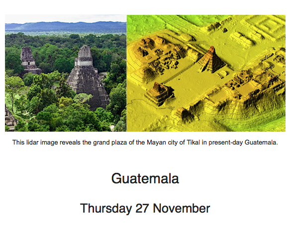
Thanks to LiDAR, the 8c CE Greater Tikal is now thought to have had a diameter roughly the equivalent of Inner London now. Hidden beneath a rainforest, its origins may date back to the time of the sack of the ancient Elamite capital of Susa by Assyria, the destruction of the Temple of Solomon by the Babylonians, and the Greco-Persian Wars. In Mayan Petén in Guatemala, 61,480 long-lost roads, more than 417 cities, towns, and villages spread across 650 square miles, have been discovered.
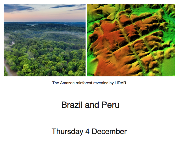
In Brazil’s Mato Grasso region, archaeologists using LiDAR found evidence of 24 sites with 81 earthworks, some up to a quarter of a mile across. The structures may have supported a civilization with up to 1 million people between the years 1250 and 1500 CE. What happened to them? In Peru the vast and much-visited site of Machu Picchu has been revealed to be much larger, and having quite different functions, than previously thought. The sister technology of Ground-Penetrating Radar (the subject of a future course!) has shown that beneath Cusco, capital of the Inca Empire, is a hugely mysterious tunnel 2.5 km deep, connecting the Temple of the Sun with the citadel.
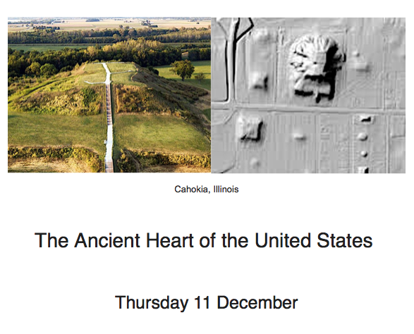
The mounds of Cahokia, near St Louis Missouri, represent the largest pre-Columbian earthen construction in the Americas north of Mexico, dating back to the 9c CE. Agricultural settlements first appeared in the area around 400 CE. LiDAR has revealed that by around 1050 CE the ancient city state spread far beyond the mounds as a major political and cultural centre, encompassing about 6 square miles and housing at least 20,000 people. But by 1350 Cahokia was gone. The extraction of sediment cores has now revealed its decline corresponds to the timing of Mississippi River megafloods. We set it in the context of other surprisingly ancient cities in the USA, from the Taos Pueblo to Canyon de Chelly.
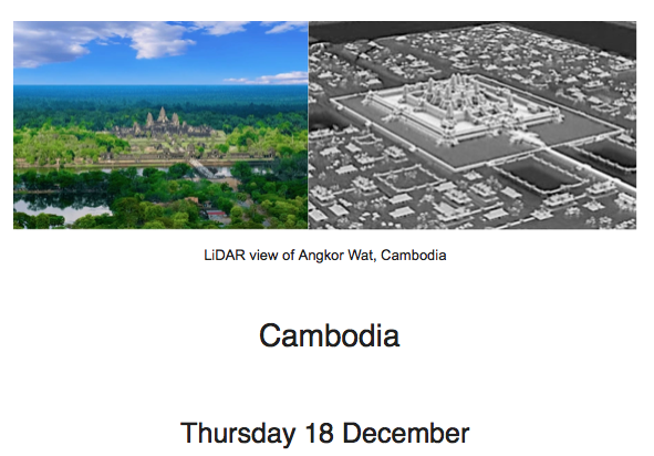
Piercing the impossibly thick jungle vegetation of Cambodia, LiDAR has shown that the famous 12c temple complex of Angkor Wat was only the centre of a city at least 30 miles in diameter (about twice the size of Birmingham). Meanwhile Ground-Penetrating Radar has indicated the presence of incredibly elaborate canal systems, vast reservoirs of water and buried towers.
Information:::::::::::::::::::::::::::::::::::::::::::::::::::::::::::::::::::::::::::
‘Revelations of the Past’ is a Zoom course (for which we offer support to access) which has been developed by Louise Friend and will be presented by Nicholas Friend. It is held on Thursdays, beginning on Thursday 6 November 2025 at 5pm and ending on Thursday 18 December 2025 at 5pm. Please note the time of 5pm: Nicholas will be lecturing from California (at 9am his time) for the duration of this course.
If you book for the course but cannot manage a particular date, then be assured we will be sending recordings of sessions to all registered participants. Each session meets from 15 minutes before the advertised time of the lecture, and each lasts roughly one hour with 15 minutes discussion.
COST: £350 for all seven for members, £420 for all seven for non-members. All sessions are limited to 21 participants to permit an after-lecture discussion session.
make your payment to Friend&Friend Ltd by bank transfer to our account with Metrobank, bank sort code 23-05-80, account number 13291721 or via PayPal to nicholas@inscapetours.co.uk, or credit/debit card by phone to Henrietta on 07940 719 397. She is available on Tuesdays or Thursdays between 2-5 pm.
How to Set Up a PayPal account::::::::::::::::::::::::::::::::::::::::::::::::::::::::::::::
Click on this link: https://www.paypal.com/uk/home
In the upper right-hand corner of the screen, click “Sign up.”
On the following screen choose “Personal account” and click “Next.”
On the next page, you’ll be asked to enter your name, email address and to create and confirm a password. When finished, click “Next.”
Click “Agree and create account” and your PayPal account will be created.
How to Connect your Bank Account to your PayPal account:::::::::::::::::::::::
Log on to your account and click the “Wallet” option in the menu bar running along the top of the screen.
On the menu running down the left side of the screen, click the “Link a credit or debit card”.
Enter the card information you wish to link to your PayPal account and click “Link card” for debit card.
How to Send Money::::::::::::::::::::::::::::::::::::::::::::::::::::::::::::::::::::::::::::::::
Log on to your account. Click Send & Request.
Enter the email address of the person you wish to send money to: nicholas@inscapetours.co.uk
Type in the amount you wish to send, click continue then press ‘Send Money Now’.
